Monday, August 31, 2015
Obama To Appear On Survival Expert's Show
During his upcoming visit to Alaska, President Obama will join survival expert Bear Grylls on an episode of his show Running Wild With Bear Grylls. Grylls has been a member of the British special forces and had an earlier show named Man v. Wild. If anyone has recently told Obama to take a hike, it appears that he intends to do exactly that. Although I've never a fan of Obama, I hope that Grylls is the only bear that he runs into.
Sunday, August 30, 2015
Sunday Links
Some things going on out there:
From CNN, New Jersey Governor and presidential candidate Chris Christie (R) promises that as president, he will "track undocumented immigrants like FedEx packages". This begs several questions. In order to start such tracking, don't we have to first find them, which according to some people, can't be done for all 11 million of them? And if we can find them, wouldn't this enable us to deport them?
From Breitbart Texas, Harris County Sheriff Ron Hickman addresses the #BlackLivesMatter "rhetoric".
From Reuters, Sheriff Hickman states that Deputy Darren Goforth was "killed because of [his] uniform".
From Independent Journal Review, Milwaukee County, Wisconsin Sheriff David Clarke accuses President Obama of starting a "war on police".
From the Chicago Sun-Times, General Mills announces its goals for cutting greenhouse gases.
From Arkansas Online, the University of Texas has removed its statue of Jefferson Davis from its place near the university's clock tower.
From The Sun, a British MI6 spy who was found dead five year ago had hacked into data on former U.S. President Bill Clinton.
From The Weather Channel, in a historical rarity, there are three Pacific hurricanes now in category 4. (via End Time Headlines)
From US of Arn, Representative Adam Kinzinger (R-IL) faults Senator Dick Durban (D-IL) for supporting the Iran nuke deal.
From WQAD, a small plane crashes near Kewanee, Illinois.
From Middle East Online, for the first time ever, woman in Saudi Arabia will be allowed to vote in local elections.
From the Chicago Tribune, Wisconsin Governor and presidential candidate Scott Walker (R) thinks that putting a wall on the U.S.-Canada border "merits further review".
From Fox News, some Appalachian Trail hikers have been "behaving badly". (Having hiked all of the Maryland part of the trail, and a few miles into both Pennsylvania and West Virginia, I naturally find this news rather disconcerting.)
From the St. Louis Post-Dispatch, hundreds mourn for a 9-year-old girl killed in Ferguson, Mo. (via ABC News)
And from the New York Post, a resident of the Hamptons, a very rich and very leftwing area of Long Island, has had to take extraordinary measures to protect his "Hillary For Prison" signs.
Friday, August 28, 2015
Migrants In Europe Helped By Smartphones
Here's an interesting story about the migrants traveling in Europe that came out in The New York Times three days ago, and was picked up by VDare a day later. From the Times:
The tens of thousands of migrants who have flooded into the Balkans in recent weeks need food, water and shelter, just like the millions displaced by war the world over. But there is also one other thing they swear they cannot live without: a smartphone charging station.Among other things, the smartphones help them connect with traffickers. Also from the Times:
On the Arabic-language Facebook group Trafficking to Europe, one trafficker offers a 50 percent discount for children under 5. The 1,700 euro price of the journey from Istanbul to Thessaloniki, Greece, about $1,900, includes travel by car to and from each side of the border with a two-hour walk across.Not only is a lot of illegal immigration going on, but there appears to be a pretty sophisticated network ready to support it, or at least make money off it. So much for the stereotype of such migrants being poor or fleeing poverty. Read the full story.
Migrants Die In Separate Incidents
Some of the invaders migrants trying to reach Europe or travel between its countries have seen their travels come to a grim end.
From BBC News, two boats carrying a total of about 500 people capsized near Libya. So far, 82 of them have been reported dead, with around another 200 still missing.
From AOL, 71 migrants appear to have suffocated in a refrigerated truck abandoned on a highway in Austria.
From BBC News, two boats carrying a total of about 500 people capsized near Libya. So far, 82 of them have been reported dead, with around another 200 still missing.
From AOL, 71 migrants appear to have suffocated in a refrigerated truck abandoned on a highway in Austria.
Wednesday, August 26, 2015
Virginia Journalists Killed During Broadcast
Two journalists in Virginia were shot and killed while they were conducting an on-air interview this morning around 6:45 a.m. at Bridgewater Plaza in the town of Moneta. Reporter Alison Parker and photographer Adam Ward were employees of WDBJ, based in Roanoke.
I first learned about this horror at Hot Air, who provide links to WSLS and WDBJ. You can also read more at The Epoch Times.
UPDATE: The person being interviewed, Vicki Gardner of the Smith Mountain Lake Regional Chamber of Commerce, was also shot and hospitalized. The suspect, identified as Vester Flanigan, shot himself near mile marker 17 on Interstate 66, and is reported to be in critical condition. This would mean that he fled about 150 miles to the northeast after the shooting in Moneta.
UPDATE 2: Hot Air has now linked a live blog by The Washington Post. According to an entry timed at 1:58 p.m., the suspected shooter has been pronounced dead.
Tuesday, August 25, 2015
Some Sights In Western Colorado
To conclude my most recent travelogue, I have a few pictures from places in Colorado where I made a brief stop. In Fruita, there is a welcome center just off exit 19 from Interstate 70. Across a parking lot from the welcome center is the Western Slope Vietnam Memorial Park, which is easily spotted because of its mounted Army helicopter. More on this memorial may be found at Pauahtun and Roadside America.

While driving though Grand Junction, I came across the Museum Of Western Colorado and paid a short visit. The museum includes this tower next to its entrance.

Also near the museum's entrance was this replica of an old steam engine. The artwork on the wall has an American Indian motif.

A mile or so east of exit 49, Interstate 70 goes into these tunnels through Beavertail Mountain. Eastbound traffic has the option of leaving the main road and going into what is called a "parking area", from which the tunnels may be photographed. The "parking area" is a single lane and shoulder which, like the Colorado River, goes around the mountain, before merging back into the main road.

In the small town of Collbran is the American Servicewomen's Memorial.

In the even smaller town of Mesa, along Colorado State Route 65, are these two statues of horses, which I think are made of bronze.

Thus concludes my Colorado-Utah travelogue.
Crayfish Species Named After Edward Snowden
Former NSA contractor Edward Snowden, who might be a hero, freedom fighter or traitor depending on whom you talk to, has been given a new namesake, a species of crayfish native to the Indonesian part of New Guinea, the Cherax snowden. Specimens of this animal have previously been mistaken for members of another crayfish species. The crayfish has a dark blue body with orange on parts of its extremities, and thus does not physically resemble Snowden. Whether any have been found leaking secrets has not been reported.
Read more at Sci-News, UPI, The Washington Post and Time.
Read more at Sci-News, UPI, The Washington Post and Time.
Monday, August 24, 2015
Some Sights In Eastern Utah
The entrance to Arches National Park is just off U.S. Highway 191, a few miles north of Moab, Utah. Between the park entrance and Moab is the junction of U.S. 191 and Utah State Route 128. From the junction, U.S. 191 goes northwest, while Utah 128 goes northeast, both of them eventually connecting to Interstate 70. Most of Utah 128 follows the Colorado River on its east side. About 30 miles north of its southern end, the road goes over a bridge and onto the west side of the river. After a few more miles, Utah 128 and the Colorado part company, with the road proceeding northward across a relatively flat area before coming to a T. Turning left keeps you on Route 128 and after a few more miles, takes you to I-70. Turning right puts you on an unnumbered road which also goes to I-70, after passing through the remote town of Cisco.
Much of Route 128 along the Colorado is in a canyon. There are also some rock formations along the road, such as these, about two miles south of the bridge.

The bridge itself is a replacement for an earlier suspension bridge, called the Dewey Bridge. Its remains can be reached via a short side road near the modern bridge. This is the tower on the east side of the Colorado.

This marker indicates that the Dewey Bridge has been placed on the National Register of Historic Places.

Standing under the east tower, I could see the west tower and the remaining cables.

After crossing the modern bridge and continuing northward for about two miles, I came across this rock marked with Indian petroglyphs and some modern graffiti. There was no road sign about "Indian Writing" or anything else. The stone simply caught my eye.

Black Monday Links
The stock market, already having taken a beating last week, opened today with some big losses. Here are some stock market stories and other things in the news:
From Fox News, the Dow-Jones opened over 1,000 points down, but as of 9:50 a.m., has a net loss for the day of 611 points.
From The Street, the S&P 500 undergoes a correction.
From WUIS, a live blog of today's stock market action.
From CNBC, as the Dow, Nasdaq and S&P all suffer losses, the New York Stock Exchange invokes Rule 48.
From Zero Hedge, Rule 48 is invoked. The site also shows the text of this rule.
From Bloomberg Business, stock trading will pause for 15 minutes if the S&P goes down by 7% before 3:25 p.m.
From International Business Times, the "Fab Five" tech stocks all get crushed.
From The Jerusalem Post, European stocks suffer large losses.
From Market Watch, since last Wednesday, the Euro has made up half of its year-to-date loss against the dollar. (Good thing I visited Europe two months ago instead of last week.)
From The Vancouver Sun, in a survey, economists believe that the Federal Reserve will raise interest rates this year.
From The Washington Times, presidential candidate Donald Trump (R) not only enjoys good poll numbers, but bad poll numbers among those who attacked him.
From CBS Chicago, mosquitoes in McHenry County, Illinois have tested positive for the West Nile Virus.
From BBC News, a huge chunk of ice has broken off Greenland's Jakobshavn Glacier.
From io9, data collected in 1995 provides evidence that rogue waves exist.
From AOL, the three Americans and one Briton who stopped the attack on a train travelling to Paris were awarded France's Legion Of Honor medal.
From MyChamplainValley, who indicate CNN as their source, what we know about the train attack suspect.
From National Review, in Big Technology, Americans need not apply.
From Yahoo News, Guatemalan President Otto Perez, accused of corruption, refuses to resign.
From The Washington Post, ISIS destroys another ancient structure in Palmyra, Syria.
From Reuters, convicted theater attacker James Holmes will be formally sentenced in a three-day hearing that begins today.
And from The Washington Free Beacon, voters in Florida, Ohio and Pennsylvania oppose the Iran nuke deal by 2-1. (What their congresscritters think of the deal is another matter.)
Sunday, August 23, 2015
Back To Arches - Part 2
After viewing Tunnel Arch and Pine Tree Arch in the Devils Garden area of Arches National Park, as told in Part 1, I got back on the area's main trail and hiked to the viewing area of Landscape Arch, one of the park's most famous arches. There's a long sloping area that goes under and behind it, leading up to an alcove.

From the same viewing area, you can see Partition Arch.

Here's another shot of Landscape Arch, from a slightly different angle.

Some trees and rocks were near the Landscape Arch viewing area.

From the viewing area, there is a primitive trail leading uphill toward some other arches. I wandered up the trail until I came to this area, where an arch had fallen in 2008, according to a ranger who was standing on the trail. The arch had been attached to the near end of the rock formation that takes up most of the next picture. The young hikers are on the primitive trail, which continues to the right of the formation.

After viewing Tunnel, Pine Tree and Landscape Arches, I hiked back to the Devils Garden trailhead. On the way, someone pointed out this little guy. For a second there, I thought I was in a Geico ad.

I just had to get another shot of the lizard and his rock, from the other side.

While driving back to the park's entrance, I stopped to see the Fiery Furnace. It was now early afternoon, at which time this feature received more direct sunlight than in the morning.

Although I had photographed it two years earlier, I had to again stop and see Balanced Rock and its environs on my way out.

Back To Arches - Part 1
During my trip to western Colorado and eastern Utah, from which I just got back, I went back to Arches National Park, which I had visited two years ago. This gave me a chance to see some things that I had not seen during my first visit. This time, I arrived in the morning, rather than during the afternoon, thus being provided with sunlight from a different angle. This would in turn help determine which of the park's features would be easier to photograph. One example would be the Three Gossips, which was in shadow as seen from the park's main road two years ago, but this time was in sunlight.

These formations are in an area called the Rock Pinnacles.

This is another of the Rock Pinnacles.

This rock column, one of the Pinnacles, was pretty close to the road.

I headed for the northern end of the main road, to see the area known as Devils Garden. There are several arches that may be reached from the trailhead via an easy well-maintained trail. One similarly easy branch trail leads to a place for viewing Tunnel Arch.

Another easy branch trail leads to Pine Tree Arch.

If you step carefully, you can walk right under Pine Tree Arch.

There's more to come in Part 2. If you wish to review my first visit to Arches N.P., click on "2013" in the Blog Archive and then on "August".
Friday, August 21, 2015
Black Canyon Of The Gunnison - Part 2
After viewing the canyon of the Gunnison river from Gunnison Point, and hiking the Oak Flat Trail, I drove to some other viewing points within Black Canyon of the Gunnison National Park. This picture was taken from a viewing area called Pulpit Rock, looking eastward. The reason the south side of the canyon (on the right) is more eroded than the north side is that the north receives more direct sunlight than the south, which causes more water to evaporate therefrom. The dryer rock is more difficult to erode, while the moister rock on the south side erodes more easily.

Looking westward from Devils Lookout, I could see the far wall of a side canyon, toward the left, and the north wall of the main canyon.

From another spot in Devils Lookout, I could see down to the Gunnison River.

Looking eastward from Chasm View, I could see part of the river, which was otherwise behind part of the canyon's south wall.

Seen from another part of Chasm View, the river turns into rapids that run between rocks.

Within easy walking distance from Chasm View is Painted Wall View. This is part of Painted Wall, named because of its two colors of rock. According to the information provided at the viewing area, this cliff is about twice as high as the Empire State Building.

Here's more of Painted Wall, looking downward into the canyon.

Painted Wall View was the last place in the park where I decided to stop and see the sights. Soon afterwards, I was back out on the road.
Man Opens Fire On Train In France
On a high-speed Thalys train travelling from Amsterdam to Paris, a man reportedly armed with a Kalashnikov and knives wounded two passengers before being tackled by two U.S. Marines. One victim was an American, the other a Briton. A French actor was also wounded by glass he broke in order to sound an alarm. The alleged shooter, of north African origin, was arrested at Arras in northern France.
In English, read more at BBC News, The Guardian and The Telegraph.
En français, lisez plus à La Montagne et Le Monde.
In English, read more at BBC News, The Guardian and The Telegraph.
En français, lisez plus à La Montagne et Le Monde.
Black Canyon Of The Gunnison - Part 1
Black Canyon of the Gunnison is a National Park situated along the Gunnison River in western Colorado, and includes one of the steepest canyons in the United States. Like the larger and more famous Grand Canyon in Arizona, the park may be accessed from either side of its respective river. Unlike the Grand Canyon, there is no bridge across the river. Anyone wishing to go down to the Gunnison River, which is far below the park's designated trails, needs to acquire a permit.
I decided to enter the park from its southern entrance, since from the south side, I could look at the canyon with the sun behind me. The north side would thus be largely in sunlight, although the rugged shapes of the canyon's walls, their steepness, and the bending of the river would result in some areas still being in shadow. Near the South Rim Visitor Center is a viewing area called Gunnison Point. From there, I took this shot across the canyon, showing some land beyond its north side.

This picture includes some trees in the foreground, and a little bit of the river.

There were some crags and boulders on the near side of the river.

A vertical column of rock stands in a small side gully.

After leaving Gunnison Point, I hiked the Oak Flat Trail, which makes a two-mile loop starting near the visitor center. As I had previously experienced in the Grand Canyon and Bryce Canyon National Park in Utah, I subjected myself to the first law of canyon hiking: What goes down must come back up, after you're already tired. Early in the hike, the trail led over a small area of exposed rock, of two different types and colors.

From one place along the trail, I could see some more of the trail below me. After a while, that's where I was. Another section of the river is in the background.

As the trail led back upward, I could see some rock formations on the near side of the canyon.

Not long after taking that last picture from the trail, I made it back to the visitor center and then drove off to other parts of the park.
Thursday, August 20, 2015
Evidence Of The Past Along Utah 279
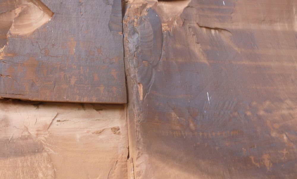
Besides the trail to Corona Arch, there are several other points of interest along Utah Route 279 south of Moab, the result of activity by earlier people and by now-extinct animal species. The two light-colored three-pointed footprints in the large slab of rock are from a dinosaur.

On one side of Route 279 is a panel of petroglyphs. Road signs call them "Indian Writing".

On the other side are the Colorado River and more rock formations.

More petroglyphs appear on two adjacent panels of rock.
Thursday Links
Some things happening out there in the world:
From Real Clear Politics, why are voters giving presidential candidate Donald Trump (R) a chance?
From Daily Surge, Trump talks politics with Oprah Winfrey - in 1988.
From the Washington Examiner, presidential candidate Ben Carson (R) draws big crowds in Arizona.
From USA Today, stocks appear set to fall in part due to lower oil prices.
From the Associated Press, a scuba-diving drug smuggler used a partially underwater tunnel.
From BBC News, two suspects in the bombing of a Hindu shrine in Bangkok turn themselves in.
From Tech Crunch, Mesosphere and Microsoft combine to bring the former's container-centric program to the latter Windows software.
From Newser, in my principal ancestral country, seven people are killed when two planes full of skydivers collide.
In FrontpageMag, Michelle Malkin points out how polluting the Animas River is not the only problem with the EPA.
From Russia Today, South Korea evacuates civilians after exchanging artillery fire with North Korea. (via End Time Headlines)
From The Jerusalem Post, Malaysia has arrested ten people with suspected links to ISIS.
From LifeNews, media networks censor a video of a woman alleging that her superior at Planned Parenthood harvested organs from a baby that was still alive.
From Reuters, existing home sales are at an eight-year high.
From The Washington Post, Tropical Storm Danny could become this year's first hurricane.
From the New York Daily News, a baby was accidentally locked in a hotel safe. (via NJ(dot)com)
And from Hokiesports, the Football Writers Association of America's 75th Anniversary All-America Second Team includes the man known as Bruuuuuuuce.
Wednesday, August 19, 2015
Hiking Near Corona Arch
Southwest of Moab, Utah are some arches that are not part of Arches National Park. Two of them can be reached by, or at least seen from a trail that leads from a parking lot along State Route 279, which follows the Colorado River south of Moab. First, you have to cross some railroad tracks.

After continuing along the trail for a little bit, I could look back toward my left and see how the tracks follow the Colorado. In the other direction, the tracks go away from the river and eventually into a tunnel.

Here's a large rock formation, including an alcove near its top, looking left from the trail.

Further down the trail and to the right is another rock formation with an alcove.

There were many cairns (artificial rock piles) marking the trail. In one place, there were hundreds of them.

This is Corona Arch, with a rock wall behind it.

I'm not sure if this formation is called Bow Tie Arch or the Little Rainbow Bridge.

As I was getting back to the trail's parking lot, I saw this formation that includes several domed peaks and two alcoves.

Subscribe to:
Posts (Atom)