Capulin is the name of an extinct volcano in northeastern New Mexico, which is now a national monument, and of a small town about three miles to the south. Because it's over 100 miles from Taos, just getting there was a pretty good ride. I took U.S. Highway 64 east from Taos, which led through several mountain passes and the towns of Angel Fire, Eagle Nest and Cimarron.
In Cimarron, I stopped at a small roadside store to pick up some sunscreen, a snack, and a bottle of water, which I naturally intended to refill. The cashier and one customer briefly talked about a place called Maloya, which sounds just like Maloja, the name of a town and adjacent pass in Switzerland through which I had traveled a year ago, so I told them about it. After my purchase, I continued eastward on US-64, which at times joined up with I-25 and US-87. The rest of the way to Capulin was relatively uneventful. From the town, New Mexico 325 led northward toward the volcano.
I found a spot along NM-325 to take a shot of the volcano from a distance. You can see a road spiraling up the side.
From the upper parking lot, I could see a group of hikers reaching the bottom of the volcano's crater.
I then began hiking the rim trail, going clockwise. Looking toward the northwest, I could see this nearby mountain, which I believe is Robinson Peak.
Continuing on the rim trail, I could see the town of Folsom to the north, and what looks like another volcanic cone.
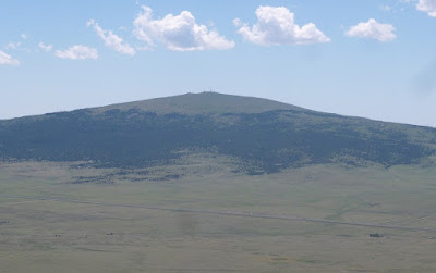
I eventually got around to the southeastern part of the rim, from which I could see Sierra Grande. The road in front of it is both US-64 and US-87.
Along much of the rim trail, the view inward was obscured by trees, but I eventually found a place where I could again see the interior. From this spot, I could see the trail from the upper parking lot down to the bottom.
From the southwestern part of the rim, I could see these natural walls of lava rock.
I completed my rim trail hike and then continued to the bottom of the crater, which included this display.
Here are some of the rocks at the bottom, along with some vegetation.
Having taken my last intended picture, I had one last chore - pulling myself back up to the parking lot. But without too much further difficulty, I was soon back on the road again. More about Capulin Volcano may be found at Encyclopædia Britannica, Desert USA and The American Southwest.


No comments:
Post a Comment