After my visit to Friendship Hill in southwestern Pennsylvania, I went south into West Virginia and then westward to Ohio. The first thing I wanted to see was a small chapel located just off U.S. highway 50, a few miles east of Coolville and near a rest stop. Driving west, I turned left onto a side road and then right into the rest stop. The chapel was on the other side of the side road.
According to a nearby sign, the chapel was the smallest church in Ohio. After getting a good look, I thought that it was even smaller than the self-proclaimed "world's smallest church" near Festina, Iowa, which I visited two years ago. You can go to the blog archives for June 2014 to look up my post for that visit.
In this first shot, I included the chapel and its sign. I don't think I got the contrast between the sign's lettering and white background very well.
I took this picture of the two sunlit sides of the chapel. That is indeed a truck parked at the rest stop, in the background to the right.
The front inside includes a painting of Christ on the cross, a pulpit, and two short railings adjoining the side walls.
My next destination was quite a bit more off the beaten path. I stayed on US 50 and then turned north on Ohio highway 278. I drove through a small town named Zaleski (which means "beyond the forest" in Polish, and is thus roughly equivalent to the Latin name "Transylvania") and then about three more miles before turning right onto Shea Road. I quickly saw a sign that indicated 2.6 miles to where I wanted to go, but the road turned from pavement to gravel after only about a mile. It was also only about one and a half lanes wide, and included a curve that twice intersected a rail trail. Fortunately, when I got to my intended parking spot, there was a shoulder area large enough to accommodate several vehicles. Even more fortunately, it was empty when I got there. I parked, found the hiking trail, and followed it to the Moonville Tunnel, shown here from its west end.
I walked through the tunnel, trying my darnedest to avoid stepping in mud, and took a picture from the east end, which was slightly obstructed by downed trees.
Just to the west of the tunnel is this not-yet-complete bridge, which will be part of the Moonville Rail Trail. To the left, you can see where hikers and bikers cross the creek.
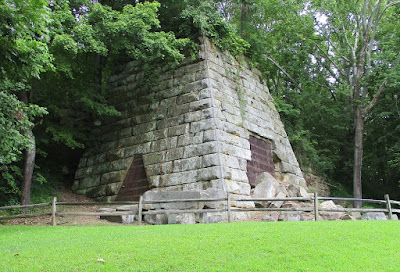
I returned via Shea Road to OH-278 and went northward about two miles to an old iron furnace within Lake Hope State Park. It has the same truncated pyramid shape as the furnaces I have seen in Maryland. Here are the furnace, a walkway, a historical marker, and a drinking fountain.
Here's the front of the furnace, close up. A metal mesh covers the main opening.
From a different angle, you can see a side opening, also covered by a mesh.
The Hope furnace was used to make iron weapons during the Civil War. For more about the Hope furnace, go to Grave Addiction, Ohio Exploration and The Ghosts Of Ohio.


No comments:
Post a Comment