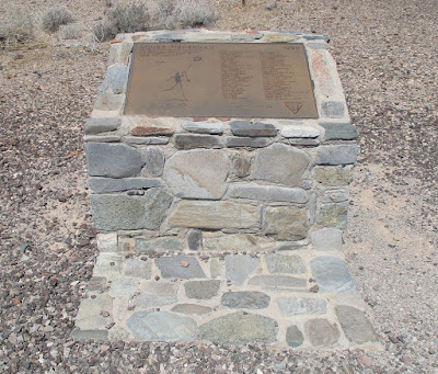
Today I drove from Phoenix westward to the town of Quartzsite, through which Interstate 10 passes. I successfully found several places that I wanted to see. Two of them are close to each other and just over 10 miles from Quartzsite itself. I reached the first one by hiking in the desert from a parking area on Plomosa Road, which is connected at its west end to state route 95 about six miles north of Quartzsite.
This marker showed that I was getting close to my destination, the Bouse Fisherman intaglio, the name "Bouse" coming from another town about 11 miles further northeast. A synonym for "intaglio" is "geoglyph". This is one type of rock art created centuries ago by Native Americans.
Here's the Bouse Fisherman in his enclosure, which I could have easily stepped over, had I wanted to be a [bleep]. Of course, I have way too much respect for such sites to damage them. The faint circle at the bottom left may have represented the sun.
In this shot from a different angle, the figure seems less distinct from the surrounding rocky surface.
I took a third shot of the figure. I don't know, but if permitted a semieducated guess, I'd say that the triangle of light-colored rocks toward the left is a recent modification, maybe to accentuate the head of the spear held by the figure.
For more on the Bouse Fisherman, go to Travels With Abby, The Bill Beaver Project, Echoes of the Southwest and Hike Arizona.
About a mile and a half southwest of the Fisherman is the Quartzsite Arrow, created to show pilots the way to Quartzsite, back when means for navigation were more primitive than today. It took me some effort to find the place. I wandered around for a bit, thinking that a fenced-in area was off limits, but later realizing that the place I was looking for was within the fence. After I found an opening, I walked to the north end of the formation. From the air, this "Q" and the letters behind it spell the name "QUARTZSITE".
I walked along the formation and took this pic at the "Z".
At the south end, between the two straight lines and a circle, is the actual arrow.
Near the south end of the Quartzsite Arrow is another arrow, which points north, as indicated by the letter "N". From this angle, this arrow is just beyond the "N".
For more about the Quartzsite Arrow, go to Roadside America and All Day Mom. If you're in Quartzsite, go north on AZ state route 95 (not to be confused with nearby U.S. 95) for about six miles and turn right on Plomosa Road. Just after mile marker 6, the fenced area is on the left. As implied above, the parking area for the Bouse Fisherman is about a mile and a half further down the road, also to the left. If you miss both sites and stay on Plomosa Road, you'll end up in the aforementioned town of Bouse.
After visiting the above two sites, I returned to Quartzsite to visit the tomb of a camel herder known as Hi Jolly, who passed away near the town in 1902. Although he had no connection to Egypt, the tomb includes this pyramid topped with a sheet of metal shaped like a camel.
Here's the tomb from a different angle.
From what I've been able to gather, the man known as Hi Jolly was originally from the Ottoman Empire and lived with his family in Smyrna, which today is Izmir, Turkey. Born to a Syrian Arab Christian father and a Greek mother, he was originally named Philip Tedro. He converted to Islam and went on the Hajj, the pilgrimage to Mecca, and thus renamed himself Hadji Ali. During the 1850s, the U.S. Army came up with the idea of using camels to transport men and materiel across the southwestern desert, so they hired Tedro/Ali to help create the camel corps. The men with whom he worked had a hard time pronouncing "Hadji Ali" and eventually corrupted it to "Hi Jolly". For more on Hi Jolly and his tomb, go to AramcoWorld, Roadside America, AzOffRoad, The Royal Tour and Cornerstone Environmental.


No comments:
Post a Comment