For the first in two years, I recently drove out to Harper's Ferry, the town in (at the time) Virginia where John Brown led his unsuccessful raid. Today, it's part of West Virginia. I was able to park on the Maryland side of the Potomac River, adjacent to the C&O Towpath, and walk over the river into Harper's Ferry itself, before continuing southward on the Appalachian Trail. To one side of the trail is Jefferson's Rock. In this shot, the bridge in the background is U.S. highway 340 going over the Shenandoah River, and includes a walkway forming another section of the AT. After crossing the bridge, I continued uphill for a while on the other side of the Shenandoah before turning back.
Back in Harper's Ferry, but still well above the eastern end of town, I got this shot of the two railroad bridges that cross the Potomac, my view partially blocked by trees.
The bridge just right of center includes one track and a pedestrian walkway that forms another part of the Appalachian Trail, by which I had earlier crossed over from Maryland. The bridge to the left includes two tracks that also go through Harper's Ferry's railroad station. On the Maryland side of the river are hiking trails in an area called Maryland Heights.
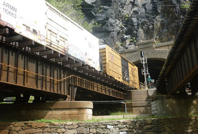
The Maryland end of the railroad bridge walkway connects to a metal stairway that goes to the C&O Towpath below the two bridges. Continuing northward, the AT joins the C&O going eastward for about 3 miles, after which the two trails split. After a slow eastbound freight train came to a stop, I took this shot from the bottom of the stairway, which led under the bridge on which I had crossed.
To see pictures from my 2012 visit to Harper's Ferry, go to the blog archive and click on "2012" and "May", under which two posts will have "Harper's Ferry" in their titles.


No comments:
Post a Comment