Today I drove northward from my undisclosed location in West Virginia and then hiked back into Maryland, or should I say, back up into Maryland. My destination was the highest natural point in the state, the Hoye-Crest summit along Backbone Mountain. To start, I parked on U.S. highway 219 near this sign. The trail begins on the other side of the road, behind the signs toward the right.
At first, I didn't see many signs on the trail, but I came upon this tree, which had a mark assuring me that I was going in the right direction. It looked like the capital letters "H" and "P" smooshed together, which stood for "high point".
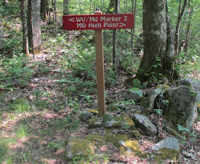
Farther up the trail, I came across this sign, which indicates that the trail goes toward both the Maryland high point and a place called "marker no. 3".
A short distance further up, the trails to the two destinations diverged.
There were no signs indicating where the boundary between the two states was. After arriving back in my undisclosed location, I could determine from GoogleMaps that everything I've shown so far is in West Virginia. Not long after this latest sign, I reached the top of the ridge and hiked the remaining distance to the top of the mountain, which is in Maryland. The summit was marked by a sign, a bench, and a cairn.
Here's a shot of the cairn. I added a small stone, but not on its highest part.
Nearby was a mailbox, which contained a notebook and several pens, so that everyone who reaches this place can register their names, residences, and dates of reaching the summit.
There was enough of a clearing on the east side of the summit to provide this long-distance view. I could see several other mountain ridges, mostly within Maryland and thus lower than where I was. There was more haze than I would have liked.
After a short rest, it was time to go back down the mountain. Naturally, this was a lot easier than going up, but I still had to be careful about my footing because of all the rocks on the trail. This post gets the "badass" label, because in a very minor act of badassery, the very minor badass is yours truly. The real badasses, however, are whoever hauled the above-depicted sign, mailbox and bench up to the summit, along with a picnic table that I did not depict. To learn more about the Hoye-Crest summit on Backbone Mountain and how to reach it, besides the link above, go to AllTrails, Peakery, Garrett Trails, SummitPost and Only In Your State.


No comments:
Post a Comment